
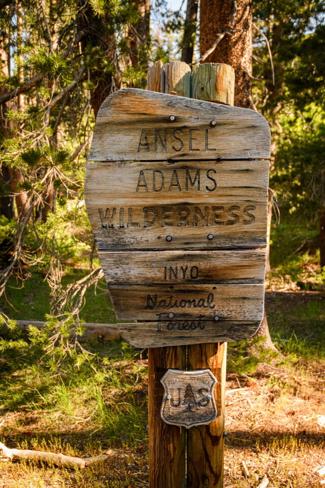
Returned from an incredible 40-mile backpacking journey through one of California’s most pristine wilderness areas – the Ansel Adams Wilderness! Named after the legendary landscape photographer, this 231,000-acre wilderness spans across the Inyo and Sierra National Forests in the heart of the Sierra Nevada mountains, offering some of the most spectacular high-alpine scenery in California.
Pre-Trip Planning and Preparation
Permits and Logistics
Planning this trip required significant advance preparation. Wilderness permits for Ansel Adams Wilderness are extremely competitive and must be reserved up to six months in advance through Recreation.gov. Daily entry quotas are strictly enforced to protect this fragile ecosystem, so flexibility with dates is crucial.
My original plan hit an immediate snag: the ESTA (Eastern Sierra Transit Authority) shuttle service hadn’t started running for the season yet in June, and road construction had closed sections of Reds Meadow Road between the entrance and Agnew Meadows stable on Monday to Friday. This meant I had to completely reroute my approach, starting from Minaret Vista instead of our planned Agnew Meadows trailhead.
Route Planning and Maps
Detailed route planning was essential for this complex three-day itinerary. I created comprehensive tracks and waypoints using CalTopo, which proved invaluable when dealing with unexpected road closures and route changes. You can view the complete route map and elevation profiles here: Ansel Adams Wilderness River Trail – CalTopo Map
Gear and Packing
With elevations ranging from 7,000 to over 11,000 feet, weather conditions can change rapidly. This year I further trimmed the gear base weight to 8.6 lbs, based on my gear set from last year.
- The water reservoir was ditched, instead I was using two Smart Water bottles, one for clean water and one for dirty. The water is much easier to get along the middle fork of San Joaquin River.
- I also brought Swayer Micro filter instead Sawyer Squeeze. It’s shorter so I can attach it to the water bottle and directly drink from it.
- 700 mL Toaks pot was replaced by 550 mL, simply because I don’t need to boil that much water for a solo trip.
- Because bear canister is mandatory, plus the consumable and camera, my total weight is about 23 lbs.
Day 1: Minaret Vista to Garnet Lake (12.8 miles, +2,388′ / -1,936′)
June 28th – Our adventure began with an 3-mile road walk from Minaret Vista down the closed Reds Meadow Road to reach Agnew Meadows Trailhead. While not the scenic start we’d envisioned, it served as a good warm-up for the challenging day ahead. The construction has been started for years but there is still no sign it will finish any time soon. If you plant to travel to Agnew Meadows, Reds Meadow, or Devils Postpile NM, make sure check the Inyo NF website for open schedule, the road is closed to foot traffic as well when it’s close for construction.
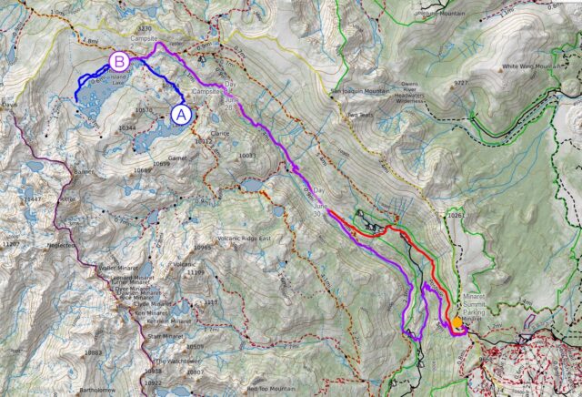
The River Trail follows the spectacular canyon of the Middle Fork San Joaquin River, immediately immersing us in classic Sierra Nevada granite scenery. The trail winds through diverse ecological zones, starting in montane forest dominated by lodgepole and whitebark pine, gradually transitioning to subalpine terrain.
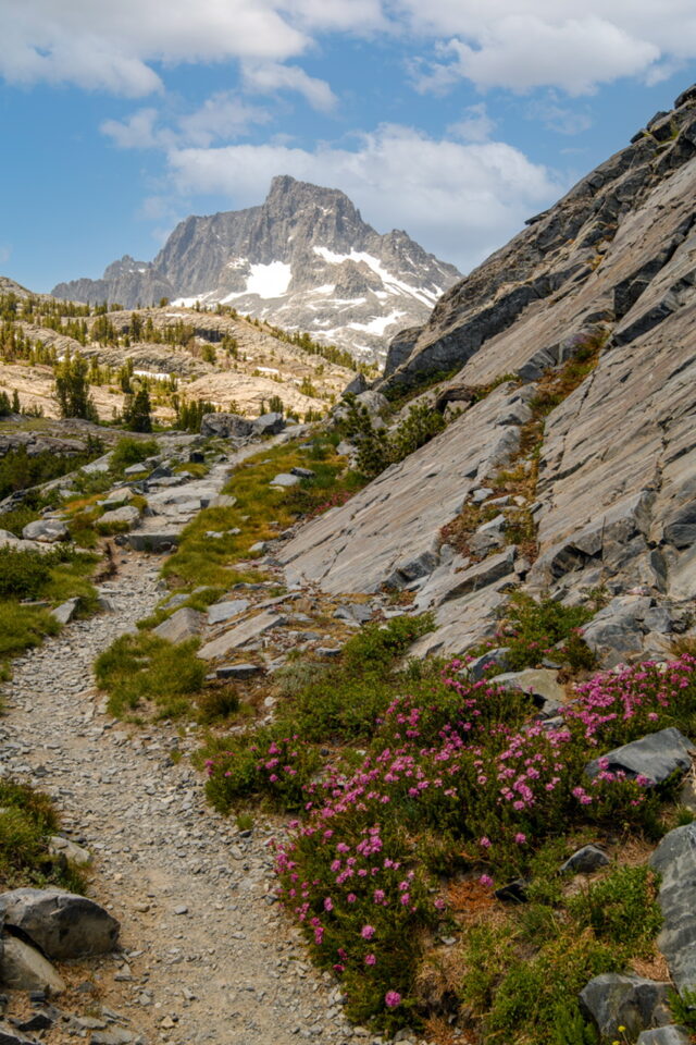
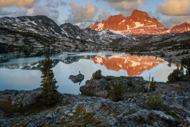
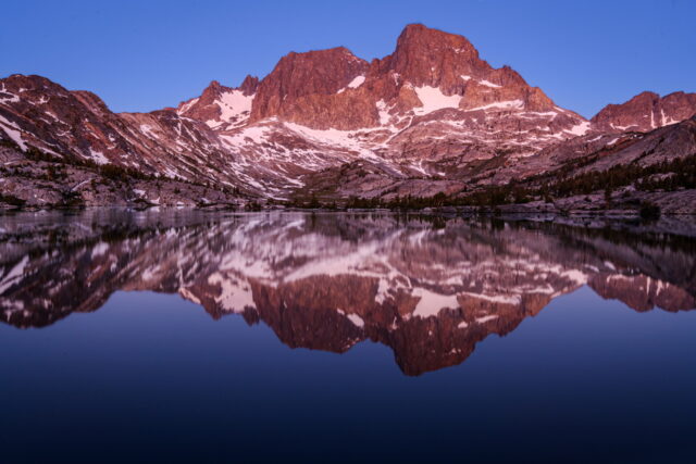
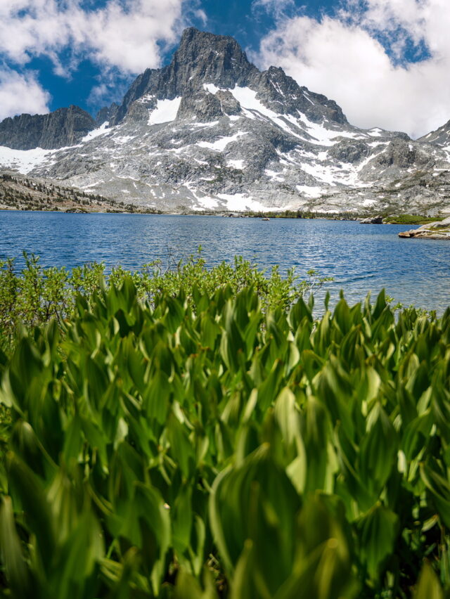
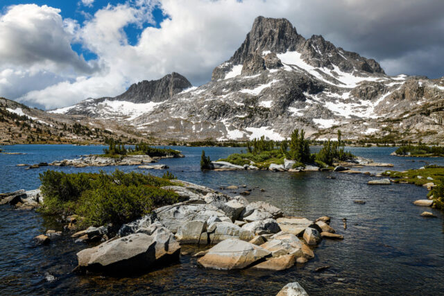
First major destination was Thousand Island Lake at 9,834 feet – truly the crown jewel of the Sierra Nevada. This glacially-carved lake, dotted with countless granite islands, perfectly embodies the pristine wilderness that inspired Ansel Adams’ most famous works. The imposing Ritter Range provides a dramatic backdrop, with their jagged peaks reflecting perfectly in the crystalline waters.
I continued another few miles to our first camp at Garnet Lake (9,700 feet). True to its name, the lake glows like a ruby gemstone, especially during golden hour when Banner Peak’s granite walls create perfect mirror reflections. The night sky here is absolutely phenomenal – with zero light pollution, the Milky Way appears so vivid it seems within reach.
Day 2: Garnet Lake Loop via Thousand Island Lake (5.8 miles, +704′ / -554′)
June 29th – A shorter day allowed us to truly appreciate the high-alpine environment. I hiked back to Thousand Island Lake and spent hours exploring its shoreline and surrounding granite slabs.
This lake represents 10 million years of geological history. The surrounding granite domes were formed from magma intrusions about 100 million years ago, then sculpted by successive ice ages into the smooth, rounded “exfoliation domes” characteristic of the Sierra Nevada. The lake itself occupies a classic glacial cirque, carved by ice that retreated only about 10,000 years ago.
The ecosystem here is both fragile and remarkable. At this elevation, the growing season lasts only 4-5 months. Whitebark pines somehow manage to survive in granite cracks, some living for centuries despite the harsh conditions. During the brief summer window, alpine wildflowers explode in color – Sierra primrose, alpine buttercup, and mountain heather create stunning displays against the stark granite.
Wildlife sightings included marmots, pikas, and numerous bird species. The area supports over 200 bird species, along with black bears, mountain lions, and other Sierra fauna. We maintained strict Leave No Trace principles, camping only in designated areas and keeping all food secured in bear canisters.
Day 3: Return via Starkweather Trail (13.8 miles, +1,926′ / -2,523′)
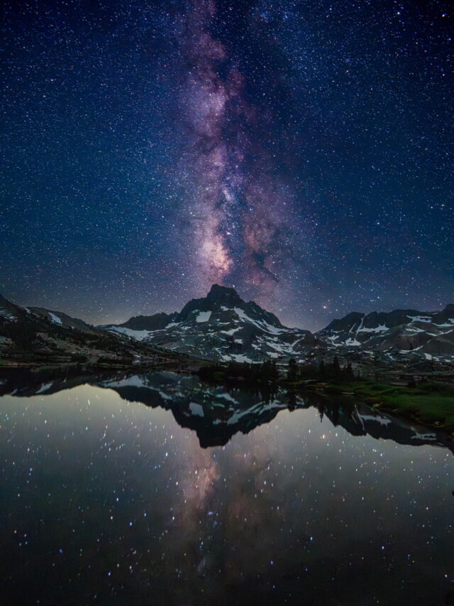
June 30th – My final day began before dawn with a pre-sunrise hike near Thousand Island Lake for photography. The 2:30 AM wake-up call was brutal after two days of hiking, but capturing the Milky Way over this iconic location was worth every groggy step. Though I only brought a lens with max aperture f/4, it still gave decent Milky Way photo in single exposure.
At 9,834 feet elevation with zero light pollution, the night sky here rivals some of the world’s best dark-sky locations. The Milky Way’s galactic core stretched dramatically across the star-filled sky, with the Ritter Range peaks creating perfect silhouettes. Using a wide-angle lens and 25-second exposures, I managed to capture the granite islands as dark sentinels beneath the cosmic display – a scene that would have made Ansel Adams himself reach for his camera.
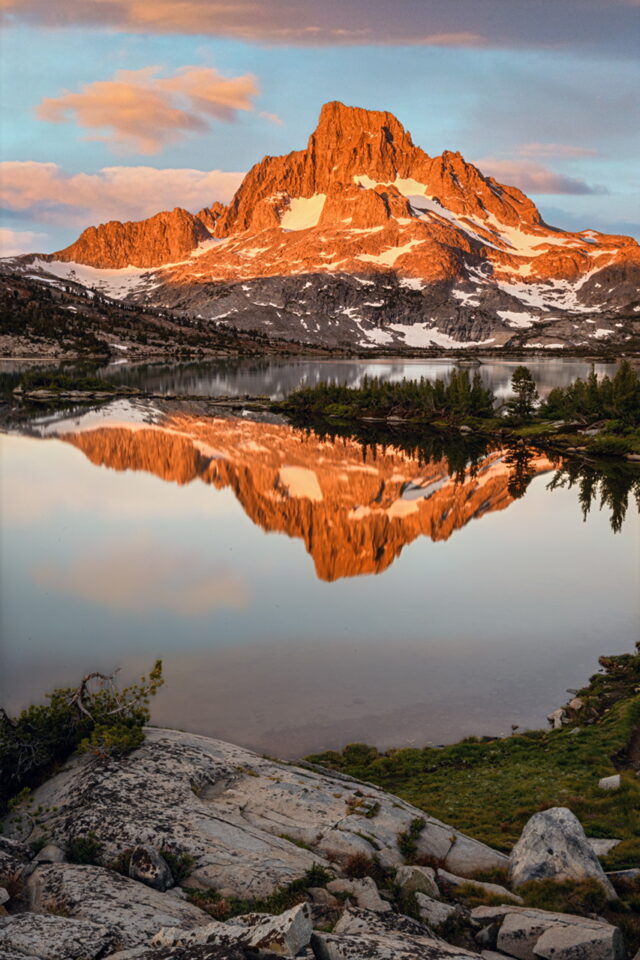
Hours later, as astronomical twilight gave way to dawn, the granite peaks began to glow with alpenglow – that magical pink and orange light that photographers dream about. Golden hour at Thousand Island Lake is truly spectacular, with the Ritter Range reflecting perfectly in the still morning waters. The contrast between the warm granite and cool blue shadows created the kind of dynamic range that Adams mastered in his legendary black-and-white work.
After this incredible photography session, our final day required another route adjustment due to ongoing road closures. Instead of returning directly via River Trail, we hiked out to Reds Meadow Trail, then took the Starkweather Trail back to our starting point at Minaret Summit.
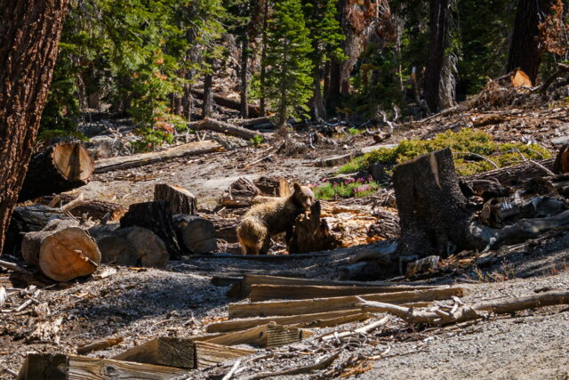
The most memorable wildlife encounter came at Starkweather Lake, just after exiting the official wilderness boundary. A beautiful cinnamon-colored black bear was foraging along the shoreline, completely unbothered by our presence about 100 yards away. These color variations in black bears are common in the Sierra Nevada – the cinnamon phase occurs in roughly 50% of the population here. We watched respectfully from a safe distance as this magnificent animal went about its business, a perfect reminder of why wilderness protection matters for these incredible creatures.
The final climb back to Minaret Summit was challenging after three days of hiking, but the panoramic views of the Sierra Nevada served as the perfect conclusion to our journey.
Wilderness Ethics and Conservation
The Ansel Adams Wilderness was originally established under the 1964 Wilderness Act and renamed in 1984 to honor the photographer who died that same year. Adams wasn’t just an artist – he was a passionate Sierra Club activist whose black-and-white photography directly contributed to the protection of numerous national parks and wilderness areas.
Today, this wilderness strictly adheres to the core principles of wilderness preservation: no motorized vehicles, no development, and even bicycles are prohibited. Access is by foot only, ensuring the landscape remains as pristine as when Adams first captured its beauty.
As backpackers, we have a responsibility to protect this irreplaceable ecosystem. Climate change is already impacting the Sierra Nevada through shorter snow seasons and retreating glaciers. Following Leave No Trace principles isn’t optional – it’s essential for preserving these lands for future generations.
Unfortunately, we observed some fellow hikers violating basic wilderness ethics: illegal campfires, improperly disposed waste, and camping too close to fragile lake shores. These actions might seem minor individually, but collectively they threaten the very qualities that make this wilderness special.
Reflections
This wasn’t just a backpacking trip – it was a profound reminder of why wilderness protection matters. Standing at 10,000 feet, surrounded by peaks that inspired some of America’s most influential conservation photography, with no cell service and only the sounds of wind and water, you understand what we stand to lose.
As Ansel Adams once said, “It is easy to take a photograph, but it is harder to make a masterpiece that will awaken the emotions of the beholder.” The real masterpiece here isn’t any photograph – it’s the wilderness itself, and our collective responsibility to ensure it remains forever wild.
The physical challenges were significant – 20-pound packs, thin air, and unpredictable weather tested our limits. But every aching muscle was worth it for the privilege of experiencing this pristine landscape that Adams devoted his life to protecting.
For anyone considering this journey: plan well in advance, prepare thoroughly, and most importantly, come with deep respect for this sacred landscape. The Ansel Adams Wilderness isn’t just a backpacking destination – it’s a cathedral of granite and sky that deserves our utmost care and reverence.